Picture this: you are facilitating a well-planned lesson in your classroom. Most of the students are engaged and working along with quiet collaborative voices. Then, you hear that familiar question, "I'm done! What do I do now?" Or, another favorite is the quiet student who just sits and doesn't do anything.
Although these won't work for everyone, I have compiled a list of interesting geography websites that students can explore. Of course, you can use these for teaching extensions, but some of them are just fun to dive into and see what you find.
Virtual Vacation
MapChart
MapChart allows you to create your own, editable, downloadable, and personalized map of the World, United States, Europe, and more! You can color code countries, states, provinces, etc on the map and then download them. Create your own legend and title. This site is free and after some playing around with it, I found it quite easy to use.
I created this map of places I have lived by using the counties section. I edited the legend to reflect how long I lived in each county. I was able to zoom in and put the state abbreviations on there as well. After previewing, I saved it to my Google Drive with no sign-in!

Not only are present-day maps available, but you can go back in time to WWI and WWII and label and save maps from that time period as well. The showcase page offers different maps that have been created by others. MapChart is great!
Native Land Digital
Native Land Digital is an interactive map that allows users to view indigenous territories, languages, and more. It is created and maintained by Native Land Digital, which is a registered Canadian not-for-profit organization. They have a majority-Indigenous Board of Directors, representing people who have close ties to land bases, communities, and deep knowledge about Indigenous ways of being and knowing. Their mission from the website: We strive to map Indigenous lands in a way that changes, challenges, and improves the way people see history and the present day. We hope to strengthen the spiritual bonds that people have with the land, its people, and its meaning. You can read more about it here.
As previously stated, the map is interactive. You can zoom in and out with your mouse and even type in a specific address to view what local nations are near. There are pull-downs for territories, languages, and treaties to view. The map is worldwide, although they are open about not being the end-all-be-all of Native Lands.
There is a resources section that also offers lesson plans, websites, and lists of the different options in their entirety. I really enjoy digging into the lists of languages and hearing and seeing the differences between them.

A view of the Haudenosaunee Land, our local native territory.
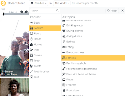
Dollar Street
Dollar Street's goal is to use photos as data to get rid of country stereotypes. This is a difficult thing to explain, so I took information directly from their website:About
Imagine the world as a street ordered by income. Everyone lives somewhere on the street. The poorest lives to the left and the richest to the right. Everybody else lives somewhere in between. Welcome to visit all homes on Dollar Street!
Background
Dollar Street was invented by Anna Rosling Rönnlund at Gapminder. For 15 years she spent her workdays making global public data easier to understand and use. Over time her frustration grew: carefully selecting data to present it in colorful and moving charts made overall global trends and patterns easier to understand. But it did not make everyday life on different income levels understandable. Especially not in places far from home. “People in other cultures are often portrayed as scary or exotic.” Anna explains: “This has to change. We want to show how people really live. It seemed natural to use photos as data so people can see for themselves what life looks like at different income levels. Dollar Street lets you visit many, many homes all over the world. Without traveling.”
Search for continents or even specific countries. You can see how people wash their hands around the world or visit a specific family from a country. There is so much to explore on this website. I love seeing the similarities and differences between people across the world.
Explore topics by using the drop-down menus. All data is photographic evidence.
**UPDATE** As always, the awesome Eric Curts can explain this site way better than I have! Check out his explanation on his weekly live video segment, here: Control Alt Achieve Live Links 1-2-2023
Radio Garden
Radio Garden is an interesting website that allows you to stream radio from across the world. Open the website to find a radio station near you, or in a specific town. The more time I spend on this site, the more I get to explore unknown areas of the world and what their radio stations are playing. Below you'll see I was exploring Europe and found stations near Reims, France. Many stations are listed and I can explore any of them I would like!
In closing, I hope you enjoy traveling the world from your computer. There are so many different websites out there to explore. I hope that you can find value in these sites for your students and yourself! Do you have other cool sites for us to explore? Let me know by commenting below!
Comments
Post a Comment